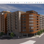
Over the past few weeks, N.C. Department of Transportation officials have showed local officials a new alternative connector route. It is the cheapest option and has the least impact on neighborhoods, but it does not achieve a critical end – separating local traffic from interstate through-traffic. Yet is is the one that local officials are considering supporting. Here’s a link to the newly posted I-26 Connector map of the route, labeled 3c, that local officials are supporting.
WHEREAS, traffic congestion and safety are increasing problems along 1‐240 and I‐26 through Asheville, a critical route for regional commerce and tourism; and
WHEREAS, local and regional residents, visitors, interstate travelers and commercial freight haulers rely on this route in ever increasing numbers; and
WHEREAS, improvements to the I‐240 and I‐26 corridor should be minimally disruptive to the local community and should enhance the quality of life for residents and visitors wherever possible; and
WHEREAS, North Carolina Department of Transportation (NCDOT) in its planning of TIP Project I‐2513 (the project), has indicated preliminary commitment to alternatives that, compared to earlier proposals, reduce relocation of homes and businesses, reduce sound impact through better deployment of sound walls and provide critically needed bicycle, pedestrian and neighborhood connectivity infrastructure consistent with local government master plans; and
WHEREAS, the NCDOT and the Federal Highway Administration have expressed openness to consider design alternatives that reduce scale and cost of the project, including the number of lanes required, should upcoming traffic demand studies warrant and justify reductions; and
WHEREAS, in the event that the selected design alternative does not include modifications to the I‐240 infrastructure on the east side of the French Broad River to support urban redevelopment, improved connection of neighborhood, and improvements to local traffic patterns; local governments will evaluate a separate future project through the French Broad River Metropolitan Planning Organization (FBRMPO) to address those concerns; and
WHEREAS, various detailed alternatives for design and implementation of the project are to be fully evaluated and provided to decision makers for formal consideration, as required under the National Environmental Policy Act in the Environmental Impact Statement, in the coming months; and local leaders, working rough the FBRMPO, can only then provide their final endorsement of any alternative; and
WHEREAS, the City of Asheville, in its five‐year capital improvement plan, has designated $1 million in co‐funding for the project to support critically needed community‐connectivity features; and
WHEREAS, members of the community have expressed their strong preference that the project soon be funded and constructed in a way that solves current congestion and safety problems while mitigating negative project impacts and addressing community needs; and
WHEREAS, NCDOT is conducting preliminary cost benefit evaluations of similar projects statewide under the Strategic Prioritization Process to establish specifically which projects will be eligible for near‐term funding of design and construction under the recently adopted Strategic Mobility Formula.
THEREFORE BE IT RESOLVED by the Board of Commissioners for the County of Buncombe and the City Council of the City of Asheville, as follows:
1. That the Board of Commissioners for the County of Buncombe and the Asheville City Council, along with the FBRMPO, hereby recommend that for the purpose of the upcoming scoring and ranking process, NCDOT use the estimated cost of $230 million associated with the preliminary 3c alignment alternative for the B section of the project; and, in preparation of the draft Environmental Impact Statement for the project, NCDOT clearly include elements that will address community needs for sound barriers and bicycle, pedestrian and neighborhood connections, including location design and the funding methodology of associated infrastructure elements.
2. That this resolution be effective upon its adoption.


It seems to me that no one is thinking about the future. Our government works extremely slow and this plan will obsolete by the time it is completed. Why not go ahead and make the big loop around town? All this traffic being forced into town is not good. Cities across the country are building outside loops to keep the traffic away from town. Look at I-240 around Winston Salem , I-285 in Atlanta and I-440 in Raleigh to name a few. Look to the future not the present. Think people!
Look at I-240 around Winston Salem , I-285 in Atlanta and I-440 in Raleigh to name a few.
If you want to flatten Beaucatcher Mountain, then I’ll spot you $20 for a shovel, and you can start digging right away.
There are some immovables about Asheville’s landscape that don’t apply to the examples you cite. If you have a feasible plan for a loop that isn’t basically I-240 and I-40, then please share it with us.
I’d like to see something done at least. In the end, there isn’t much that can be constructed as bad as the status quo.
I’ve come to agree that there isn’t much benefit to separating interstate traffic from Patton Avenue traffic, certainly not hundreds of millions of dollars worth of benefit. Even if you turn Bowen Bridge into a pretty avenue with bike lanes, sidewalks, etc, Patton Avenue west of the river is still going to be an ugly auto sewer, so in the end you haven’t gained anything other than a slight beautification of the entrance to downtown. The interchange on the east side of the river will have to rebuilt eventually too; focus on getting a good design then.
There’s not much to like about this design other than cheapness. I suppose the one nice thing is that it crosses the river further south than the old alternative 3.
I don’t like how it leaves a giant no man’s land between the two bridges along the river at the northern end. It almost seems like they’re trying to take as many properties along the river as possible. After construction, the land could then be turned into a park, but then again what use is a park that’s beneath a giant overpass?
There is another big no man’s land in front of Sam’s Club and the Crowne Plaza, between the new frontage road and the highways. I can see how this benefits the project in terms of phasing: they can basically build the entire thing without touching the existing interchange at the west end of the Bowen Bridge. This is probably where a substantial amount of the savings come from. But it seems like that huge remnant of land is just bound to become the world’s largest homeless encampment.
Also it looks like there is no way to get from east (south) bound I-26 to Haywood Road other than first getting off at the Patton Ave exit, turning right, and then heading back down the I-26 onramp.
Also putting the only entrance to Westgate as a roundabout
… will probably not be popular with the shopping center owners or the public.
Certainly doesn’t bode well for the Racquet Club and it’s members but it is a straight shot.
There’s not a color key on that linked DOT map but it *looks* like the heavy red lines are bridges. Interesting. Having looked at other alternatives, I like it.
The largest impact I see is Crown Plaza Resort will have a bridge starting right in the middle of the tennis building. But their outdoor tennis courts will now have a roof over them.
It looks like Riverside Dr., the adjacent train track and buildings along that side of the river will have a bridge over them.
They should make an exit onto Emma Rd in order to alleviate some of the New Belgium truck traffic.
This looks like a masterful clusterfuck. If cheapest doesn’t solve the core problem, why make the change at all?
The core problem is not that I-240 traffic and Patton Avenue traffic mix together on Bowen Bridge. The core problem is that I-240, Patton Avenue, AND I-26 traffic all have to mix on the bridge.
This takes I-26 out of the picture on the Bowen Bridge thereby solving the problem – without spending hundreds of millions of scarce transportation dollars for what basically amounts to a city beautification project.
In a perfect world, I-240, I-26, and Patton Avenue would each have their own bridges over the river. But given funding realities, the choice is very likely something like this, or nothing at all.
There are serious shortcomings with this design that need to be addressed, but keeping Patton and 240 traffic together is OK with me.